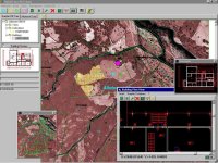
EADS Defence & Security (DS) and ESRI Deutschland GmbH have signed a new cooperation contract to combine their expertise in the area of military situational awareness capabilities and geographical data processing. Their objective is to develop an OEM product (SitGIS) and an extension product (Copex Extension), which will be marketed together on a national and an international scale.
EADS Defence & Security is the manufacturer and marketer of the Geogrid software family, containing a software product known as 'Geogrid-SitView/-COPEx' which serves to generate and process military and security-relevant situations against a geographical background, for example, for all German Army Command and Control Information Systems.
ESRI Inc. is the manufacturer of the ArcGISTM software technology The ArcGIS technology consists of individual software components (ArcObjects) which can be grouped into set products, or can be individually used within other applications (also from different manufacturers). The well known ArcGIS products ArcView, ArcEditor and ArcInfo are examples of these geoinformation products.
In the scope of the cooperation, selected components from both software products will be combined into a new product which will be marketed worldwide under the name of 'SitGIS®'. In the medium term 'SitGIS®' will become the core product of new applications in the related field of “Common
Relevant Operational Picture” (CROP).
Through the integration of tactical and analytical capabilities, users will for the first time be able to carry out tactical situation monitoring as well as complex GIS analyses for decision making, within one application.
Therefore the solution is ideally suited to support in asymmetric threat situations, to accelerate in the process of decision making, and to improve information superiority through complex analysis.