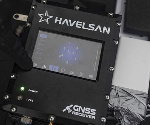
HAVELSAN GNSS was used in the 6th National Antarctic Science Expedition.
Özgün Oktar, Expedition Assistant Responsible for Logistics in the 6th National Antarctic Science Expedition, talked about the contributions of HAVELSAN GNSS.
“The HAVELSAN GNSS (Global Positioning System) receiver is an equipment that allows us to find our location, speed, and direction under any weather conditions, 24 hours a day, anywhere in the world. This is being produced in our country shows that a significant technology has been developed in our country. This year, we are here with the receiver and antenna produced by HAVELSAN. We are making measurements and trying to obtain results by comparing these measurements with other measures.”
“These results will allow us to study location accuracy, signal quality, and, more importantly, glacial changes, climate change, and distribution of particles in the atmosphere.
“HAVELSAN’s work in this regard is essential. This is a technology very few countries in the world possess. I would also like to say that I am honored to have this technology in our country,” he added.
Emphasizing that it is possible to follow the path of the signal passing through the atmosphere using the signals from the Global Positioning System, and thus, to follow the particles and the change in the atmosphere, Yavaşoğlu said: “It is also possible to monitor the region of the antenna which the signal reaches. This region may be a glacier; it may be at sea level, it may be a shoreline, a glacier in the sea, maybe sea ice. It is possible to follow all of them. We see that the receiver produced by HAVELSAN is also capable of doing these.”
Indicating that location accuracy is crucial for them, Yavaşoğlu added: “How accurate your measurements are is very important. We are doing these with one receiver, one antenna, with an accuracy on the order of centimeters, decimeters. In this sense, it is possible to say that the friends at HAVELSAN are doing a good job.”
Military and civilian platforms need accurate location information to determine where they are and calculate their routes.
Global Satellite Navigation Systems (GNSS) are primarily located in space in the form of satellites at an altitude of about 20,000 km to meet this need.
GNSS are receivers that provide location information by processing the signals they receive from satellites. It is pretty easy to make the GNSS receiver unable to generate position by jamming these signals, which are very weak on the earth's surface. Jamming devices that can be found from any platform in inexpensive and straightforward ways.


